Mandalay
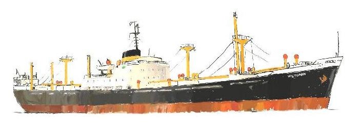
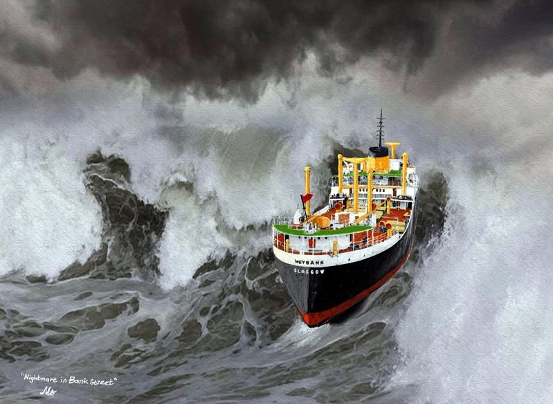
M.V. Weybank - Chapter 7
Agulhas and other rogues
The Roaring Forties are strong westerly winds found in the Southern Hemisphere, generally between the latitudes of 40 and 50 degrees. The strong west-to-east air currents are caused by the combination of air being displaced from the Equator towards the South Pole, the Earth's rotation, and the scarcity of landmasses to serve as windbreaks.
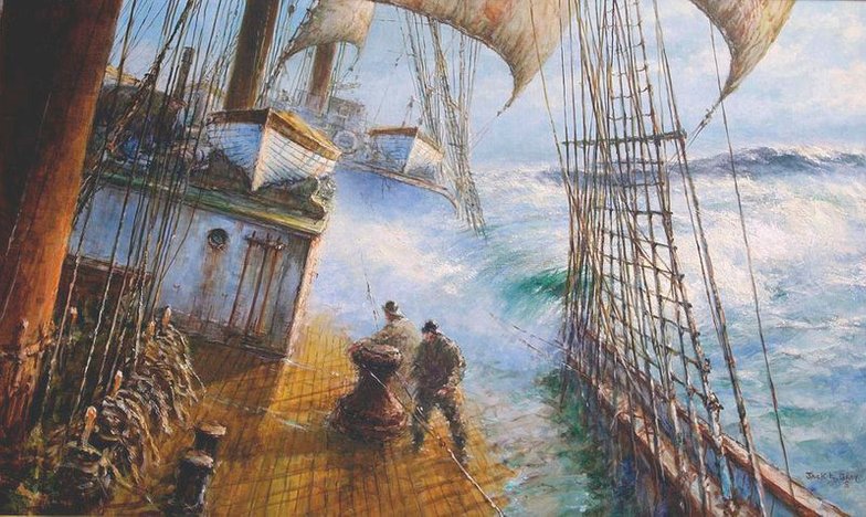
During the Age of Sail, ships travelling from Europe to the East Indies or Australasia would sail down the west coast of Africa and round the Cape of Good Hope to use the Roaring Forties to speed their passage across the Indian Ocean, then on the return leg, continue eastwards across the Pacific Ocean and under Cape Horn before sailing up the east coast of the Americas to home. The picture below is of the Roaring Forties by Jack.L.Grey.
Rogue waves are an open water phenomenon, in which winds, currents, non-linear phenomena and other circumstances cause a wave to briefly form that is far larger than the "average" large occurring wave (the Significant Wave Height or 'SWH') of that time and place.
Why am I bringing up this subject here? For two reasons - the first I explain below - the second is about the worst storm that I had ever experienced (which happened when finaly homeward bound and will describe in the last chapter).
I wrote previously about always having had good weather the many times when we sailed up or down the South African coast. Due to the winds coming up from the Roaring Forties storms were to be expected, we just never experienced one ourselves when in these waters.
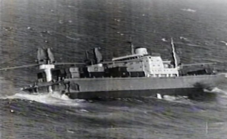
However there was a much greater hidden danger lurking along the coastal waters of SA which we were totally unaware of. Ship owners were getting concerned by the large number of incidents where rogue waves were causing serious damage to ships which were not designed to withstand such forces. The positions of the ships at the times they were hit were plotted and it was then that they saw that a great many of them had occured when sailing along the South African coast. One of these, a tanker, had a massive hole big enough to park three double-decker busses alongside each other punched midships right through one side of the ship and out the other. Yet another tanker had its complete forecastle shorn off. The ship shown below had the forward section of its hull blasted away.
A South African scientist Martin Grundling took up the challenge to try and find out why these waves were occuring so frequently along the SA coast. He managed to obtain a satellite infrared photograph of the SA coast and superimposed a sheet of transparent folio over it on which he marked with an X the positions the ships had been in when struck, as shown below.
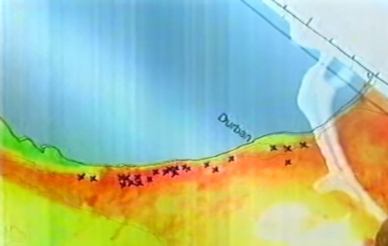
What became immediately apparent was that all the ships had been in the Agulhas current which is shown in the photo in orange/red (the strong warm water Agulhas current flows from east to west, you can read about it in Chapter 1). But what did the Agulhas have to do with rogue waves? It made no sense, not until the scientist thought about the westerly winds from the Roaring Forties flowing up NE to SA. He consulted the weather reports for the days when each of the ships had been struck and found out that on each of those days strong NE winds were flowing with their accompanying waves. On days when the wind came from the East the sea state was normal but not when it flowed up from the south-west. When the Agulhas current hit the NE flowing waves it pushed against them forcing them to build up thus generating rogues. (his theory was later verified by satellite radar technology which could measure wave height).
The conclusions about the Agulhas rogue waves made ship owners happy again because instead of having to re-design the whole world's fleet they simply directed their ships to sail around the Agulhas current. Similar vicinities around southern Norway and NE Scotland were also simply circumvented - problem solved, or so they mistakenly thought.
The oceanographic and other scientific communities generally dismissed reports from seamen who had encountered rogue waves as being analogous to fishermen's tales as in "I caught the biggest ever".
Oceanographers said they could never happen - outlandish!
A quantum mechanics physicist, Al Osborne, was intrigued by the subject of unstable non-linear waves - what caused them? To try and find out he applied a modified version of the so called Schrödinger Equation and the result was astounding. Two graphs produced by him by applying the modified equation to a computer program called MatLab are shown below.

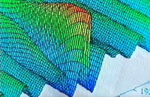
The first graph show a sequence of linear waves flowing along nicely. The second graph however illustrates how a rogue wave is formed. One of the waves starts robbing energy from its two neighbours and starts to grow while simultaneously causing the height of its neighbours to diminish. The wave has become non-linear and unstable. Not only that but the valleys between the three waves become deep and steep thus a killer wave has been born.
A ship when faced with such a wave cannot ride up its wave front as it normally would do, instead it slides down the steep surface of the wave pushing it only to be faced with a gigantic wall of water that is going to smash into it. A ship is designed to withstand a pressure of 15 tons per square meter and can generally cope with double that but a 30 meter high wave produces a pressure of 100t/sq.m. and for a ship to survive an encounter with such a monster needs a little help from the Almighty.
When Al Osborne published his findings they were just regarded with condescending ammusement by oceanographers. This however was soon about to change.
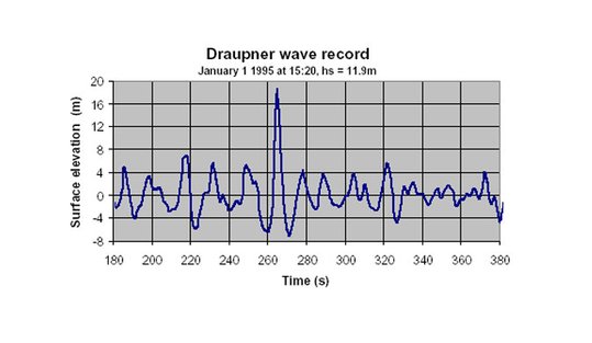
A wave that caught the attention of the scientific community was the digital measurement of the "Draupner Wave", a rogue wave at the Draupner platform in the North Sea on January 1, 1995, with a maximum wave height of 25.6 metres (84 ft). This measurement was made by a purpose designed radar mounted on the oil rig that faced down towards the sea surface and its graphical readout of the rogue wave was identical to one of the readouts from Al Osborne's findings!
Their existence has been confirmed by satellite imagery and radar of the ocean surface. In 2004 scientists using just three weeks of radar images from European Space Agency satellites found ten rogue waves, each 25 metres (82 ft) or higher.
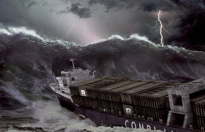
Rogue waves have now been proven to be the cause of the sudden loss of some ocean-going vessels. Well documented instances include the freighter MS München, lost in 1978 and the MV Derbyshire lost in 1980, the largest British ship ever lost at sea. The picture below was computer generated from data from a wave simulation program and shows an impression of the MS München and the rogue wave which sank her.
In February 2001 the luxury cruise ship MS Caledonian Star had just started homeward bound from the Antarctic when weather reports of gale force winds ahead were received, which did not bother the crew one bit as this was nothing out of the ordinary in these waters at this time of the year.
As the vessel progressed into the storm, riding waves over 12 meters high with ease, the watch officer suddenly saw a mountainous wall of water a mile ahead rise up 30° off the starboard bow which he estimated to be 30 meters in height. Immediately thereafter a hugh trough opened up in front of them causing the vessel to pitch downwards at an alarming angle and race into it. When the wall hit the ship it smashed through the reinforced glass bridge windows and flooding the wheelhouse washed the helmsman and watchkeeping 1st. officer off their feet. They had to fight to swim back against the maelstrom to reach the steering wheel. If the vessel turned broadside to the oncoming waves the ship could be capsized. The water in the bridge immediately short-circuited the radars, gyro compass, echo sounder, radio communications and then flowed downwards to the next decks. What saved the vessel was that the engines and steering still functioned and thus they were able to keep the vessel from floundering broadside. Although most of the superstructure was wrecked they were able to lick their wounds and slowly escape.
Within just days of each other the German cruise liner MS Bremen, also in Antarctic waters was likewise hit by a giant 30 meter wave - with devastating effect!. The wave/wall punched out bridge windows flooding the bridge electronics as with the Caldonian but much worse than that the steering gear failed and the engine shut down. She was now in desperate trouble. Without engines and steering she was unable to face the oncoming waves and instead drifted side on with a 40° list.
As the captain of the vessel later stated, if the large panoramic windows of the restaurant (which were not of the same reinforced glass as the bridge windows) were smashed through by the oncoming waves, there was nothing to prevent the sea cascading down the decks below and capsizing the vessel.
Down in the engine room under emergency lighting in the gloom and heat, the engineers were fighting for the lives of every soul aboard. The problem was with the starter generator for the main engine. It had been knocked out of action and would not start up. With the Grace of God, as any seaman will tell you, they managed to start the engine after 35 minutes and turn the ship into the wind before the restaurant glass shattered.
The Hapag owners of the vessel managed to play down the incident. When the Bremen limped into the harbour of Buenos Aires four days later a repair team freshly flown out from Germany was already waiting at the quay. Argentinian journalists who wanted to inspect the damage were not allowed to board the vessel. Instead Hapag brushed the incident off with a "Nobody was injured". The captain however said in a later interview in Germany that he had "Felt the breath of God" on that day.
Ships that pass in the night
I chose the title above to describe some of the places we briefly anchored or tied up at and in each case just for a short time.
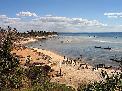
Madagascar
We only visited Madagascar twice and each time anchored off shore and only for about 6 hours before we weighed anchor. We loaded/discharged cargo into boats alongside which appeared from small settlements on the coast. The weather was beautiful and so was the coastline which was full of tropical growth and sandy beaches.
Pemba (Mocambique)
Pemba in 1968 (not to be confused with Pemba Island next to Zanzibar), was a small town in what was then still Portuguese Mocambique. It was close to the border of Tanzania to the north. Each time we made a round trip from Calcutta to Capetown, we stopped at Pemba on both legs of the trip but we only dropped anchor for a few hours in Pemba Bay before continuing on our journey. It was a very picturesque spot as can be seen from the photo below of Pemba beach at that time. As in Madagascar we never had an opportunity to go ashore.
Dhaka
We only visited Dhaka once (or Daaca as it was then called), which in 1968 was the capital of East Pakistan. There was a lot of political unrest at the time which exploded only a couple of years later in 1971 into a liberation war whereafter the country broke away from EP and became Bangladesh.
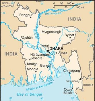
To reach Dhaka we had to navigate almost 100 miles up tributaries of the Ganges (as shown in the map above) which was similar to the pilotage up the Hooghly to Calcutta. We never reached Dhaka because many miles before, we tied up alongside the riverbank somewhere in the middle of nowhere and discharged cargo with our derricks into ox-drawn carts or onto the riverbank itself where it was manhandled. The sky was overcast the whole time and the heat around 30°C with oppressively high humidity. We only stayed until the next high tide enabled our escape.
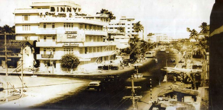
Cochin
On the southwest coast of India, Cochin was another of the ports which we only visited just once and only for a day at the most.
Below, Cochin in 1965 - what aesthetic!
The only but vivid memory I have of this visit was in the afternoon when five of the Lascar crew members returned to the ship after a short shore leave.
I was standing at that time on the main deck next no.4 hatch talking to the 1st.and 2nd.Mates when the Lascars appeared on the quayside at the top of the gangway which was slanted down towards us. At first it was hilarious as they were all stoned out of their minds and their antics trying to get aboard would have made Laurel & Hardy proud.
However, once they got their feet on the main deck, things started to get ugly.
One of them started shouting in Bengali, gesticulating wildly with his arms at the Mates which also kickstarted his four companions into action. We were told later by the Tindal (Bosun) that they had been drinking bootleg Arak ashore and, completely out of their minds when aboard again, were trying to start a mutiny amongst their fellow Lascar crew members.
They ganged up on the Mates and started to push and shove them around but Lascar crew members who had been working aboard gathered together and tried to pull "the Araks" away and subdue them. The ringleader broke free and picking up a thin plank of dunnage* suddenly focused on me. He came running up to me with the plank raised with both arms above his head and then, with some kind of Bengali war cry and twisting his body, slammed the dunnage plank onto the deck by my side just missing me by a foot (on purpose). I guess that was the signal from him to his co-demonstrators: "God, I need to lie down, I'm getting dizzy".
* Dunnage segregates cargo in the hold and prevents shifting of the cargo in response to ship motions. It is generally in the form of inexpensive or waste wood.
Beira
On one occasion when in Beira (Portuguese Mocambique), our Portuguese agent invited some of us to his Finca (Hacienda?). He picked us up in a big military jeep and then shot off inland in clouds of dust. His Finca was very impressive to say the least and awaiting us there were his family and friends who had a big long table laid out for the excellent feast that was to follow. However, the thing that remained in my mind from this visit was when the conversation turned to the war which was being fought by the Portuguese against Frelimo insurgents. I asked our host for his opinion on where it would all end. He replied by telling us that the Portuguese were ready to start construction of a massive dam* and did we think they would invest so much work and money into the project just for fun? He then stated with emotion "We will NEVER leave Mocambique!".
* When given the order to begin construction of the Cabora Bassa dam in 1969, the Portuguese forced the native people out of their homes and villages and built a small town for all the contractors, electricians, and engineers on top of the native Mozambique homes. The evicted were given no compensation. The dam, completed in 1974, was built to produce electricity for South African farms, mines, and cities. Less than a year later in 1975 Mocambique gained independence and almost a quarter of a million Portuguese left the country leaving their dreams and most of their possessions behind them.
The irony of it all is that today in 2018, the Portuguese government owns eighty-two percent of the Cabora Bassa Lake and the Cabora Bassa dam while Mocambique, the country the lake and dam lie in, owns only eighteen percent!
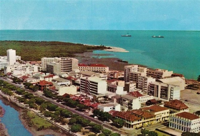
Above, a Portuguese picture postcard of Beira in the 1960's. The colouring leaves a lot to be desired!
A day or so later in the evening while still alongside in Beira, I was leaning against the rail of the boatdeck having a smoke while looking down at natives standing in a railcar unloading sacks from a cargo net which our derricks lowered. They were all fine physical specimens stripped to the waist and were singing in rhythm while unloading. When the cargo net was emptied and hauled up for the next load they got carried away and started some kind of tribal dance while still singing. This was too much for the scrawny Portuguese overseer who climbed up onto the railcar and started laying into them with a short crop whip. This stopped the dancing and singing and the overseer, satisfied with his prowess, climbed back down again. When the next load arrived the natives, undaunted, tuned up and restarted their rhythmic chanting.
This left a lasting impression on me. The natives could have made mincemeat out of the overseer but they lived day by day accepting the humiliation knowing that a single blow from the overseer's whistle would bring the ever present miltary police running. When I saw this I knew instinctively that Frelimo would prevail.
Singapore
In December 1968 when we were tied up alongside Kilindini Wharf in Mombasa we received the order to proceed to Singapore! This caused us a bit of consternation to put it mildly. We had left the UK almost eleven months ago and had been hoping (totally unrealisticaly) that we would head back at least in the direction of Europe. The Bank Line's major stomping grounds apart from India and East Africa were the Far East (loosely described mainly as Malaysia, Singapore, Thailand, Vietnam, China, Hongkong, Taiwan and Japan) but included Australia, New Zealand, the Philippines and just about all of the islands strewn across the Pacific Ocean and the Western seaboard of the USA and Canada.
Once we arrived at Singapore we would obtain further orders i.e. destination unknown. Our one and only consolation was that India finally lost her grip on us. We departed Mombasa on the 18th December on a course of 79° True which headed us diagonaly to the northern tip of Sumatra from where we would then turn south east down the Strait of Malacca to Singapore. As the speed of our ship was only 15 Kts. we would cover approx. 360 Nautical Miles(NM)/day and thus it would take us about ten and a half days at sea to reach Singapore.
The run to Singapore should have passed uneventfully apart from Xmas Day (which I described in a previous chapter) when we were about 150 NM south-east of Ceylon (Sri Lanka). I wrote "should have" because of what happened on the evening of the 21st when we were only three and a half days out of Mombasa:
Launched in 1923 betting pools were a way of predicting football results in the hope of winning hugh cash prizes. It spread nationwide like wildfire and became a massive business throughout the 60s and into the 90s with a peak of 10 million playing weekly.
Vernons of Liverpool rapidly became a big football pool although Littlewoods was the market leader. In 1961, it was Littlewoods who paid out the dizzying sum of £152,000 (£3m in modern money) to the notorious Viv Nicholson, a beehived blonde from Castleford who became a cult figure after vowing to “spend, spend, spend” (she did! and it didn't take long before she ended up pennyless!).
Before the UK National Lottery started up in 1994, the football pools were the only fast route to riches for the ordinary joe. We daydreamed about winning the jackpot, gazing in awed envy at the chosen few holding up giant cheques in the newspapers and fantasising about what we’d do with such untold wealth. Then we’d get worried about beggars, thieves and con-men, and hurriedly tick the “no publicity” box.
You could kid yourself it was a test of football knowledge, but most marked the same boxes on the grid each week - house numbers and family birthdays, like in later years with the lottery.
In the UK it was a Saturday afternoon ritual to huddle around the radio or TV for the classified football results at 5pm - this was before the days of Sky TV’s staggered kick-off times. Most punters played the “Treble Chance” game, in which the Holy Grail was correctly predicting eight score-draws. If matches were postponed or abandoned (winters were harsh, pitches muddy, undersoil heating a luxury), the fabled “Pools Panel” would adjudicate.
At the time when we left Hamburg behind us we organized a football pool (not to be confused with a swimming pool, not even a jury-rigged canvas one - another luxury we never had) aboard the Weybank.
The cost of each weekly bet was shared equally by all the members of the pool.
How was it possible to fill out a football betting slip each week and get it to the football pool company in the UK before "Rien ne va plus" on a Saturday afternoon?
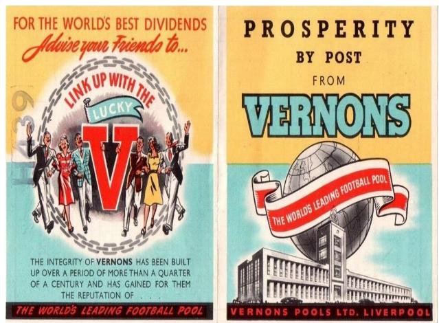
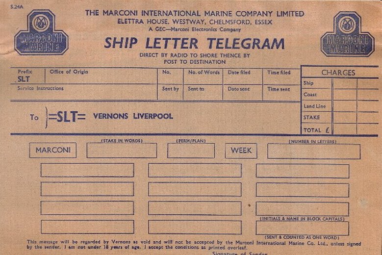
The answer to this lay in the fact that the Marconi company (that employed me) had made a deal with Vernons of Liverpool. A special telegram form of a Ship Letter Telegram (SLT) was printed out and supplied in pads to all vessels fitted with a Marconi radio station.
A normal Standard telegram was an expensive thing to send and therefore used mainly by the Master to send official information/orders/requests to shipping agents and ship chandlers etc. This type of telegram after being received by the coast station would be forwarded on via cable to a destination town's GPO and then delivered to the recipient's front door, generally by a youth on a Post Office BSA Bantam motorbike (which if I remember correctly was only 50cc - if you drove up a hill with a girl sitting behind you the bike would soon come almost to a standstill - time for her to get off and push you up the rest of the hill- or, if you had your head screwed on right, forget about the bike!).
Because the expense of a sending a standard telegram by a crew member was prohibitive, the powers-that-be came up with what they thought was a genial solution: the Ship Letter Telegram, SLT for short. A SLT pad looked just like a Standard pad except for the colour design. The SLT was blue whereas the Standard was red (i.e. danger - this will cost you!).
The trick with the SLT was that once it was received by the coast station it would be forwarded by ordinary mail to the recipient - no BSA Bantam!
The Vernons SLT form was basically configured with ten boxes to be filled in with ten of the football matches which you thought would end as draws. If eight of them turned out to be draws the following Saturday - you would have hit the Jackpot! To make it however more difficult, you had to select a Permutation/Plan, instructions on which were written on the back of the form. Vernons and their competitors (Littlewood's etc.) offered the first four English divisions and the Scottish football first division to choose the draws from.
While still in Mombasa we had filled out the SLT for next Saturday and I transmitted it to Portishead Radio in the UK - it was forbidden to transmit within the territorial waters of whichever country you visited but the Russians did it blatantly and what they can do, we can do better. "Rule Britannia - the pools must get away, Britons never, never, never shall be gay!" (couldn't find another word to rhyme with 'away').
Returning to the evening of the Saturday the 21st Dec. (three days out of Mombasa). We are approximately
62°E of Greenwich which means we are 4 hours ahead of the time in the UK. The classified football results are transmitted in the UK at 5pm (1700 hours navy speak) which equates to 9pm or 2100 our time.
I am up in the radio room with the Atalanta main receiver tuned to the BBC World Service and listening for the start of the football results. I am in no way excited because I have being doing the same just about every Saturday since we left Hamburg and with the same result - Nada Zero! Zilch! It has just become a habit but like smoking it's hard to give up.
"Leyton Orient 2, Doncaster Rovers 1; Charlton Athletic 1, Cespool 2" - on and on the announcer would slowly drone out the results with an accent like Basil Brush whilst I scribbled furiously to keep up with him on a Marconi telegram pad. Finished! End of the results - I'm exhausted and don't really care if I can decypher what I have scribbled down. Now where did I file away the Vernons SLT? Hopefully not in the Gashcan - ah yes, found it!
I start checking the results against the SLT. By the time I've found five draws which are ours I'm really starting to wake up. Three draws later - "We've got Eight!!!!" - JACKPOT! JACKPOT! - I'm going home - we're all going home! Singers, here we come and then straight to Paya Lebar airport!!"
I charge out of the radio room and down the staircase past the Captain's cabin like Quasi Modo exiting Notre Dame's belfry to save Esmeralda. Bang! Bang! Bang! I thump on each cabin door - the news spreads like wildfire. We gather in the saloon and get the beer out - I still have to finish my watch in the radio room but what the hell! Xmas is only a few days away but this is our salvation! An undescribable glow of happiness shines from each of our faces.
Only one final hurdle to take: The dividend, i.e.the sum which Vernons would pay for an eight score-draw! This sum depended on how many other "punters" had also checked eight draws.The more of these that had, the less the dividend payed out for each player. It took me a couple of days to finally find out the dividend for that Saturday. For us aboard it seemed as if half of the UK must have also checked eight draws because after our "win" was split up between us, each of us would only receive just about enough to cover the expense of a carton of duty free cigarettes. We drown our sorrows in Tuscar before that, like our luck, also ran out. Che Sera Sera! Avanti, tutta forza!!
Singapore is "My Island in the Sun". I spent much of my boyhood youth there and also as a teenager. When I left it on what I thought at that time would be forever - it was for me "Paradise Lost".
To give you an idea about Singapore and just how small the island really is:
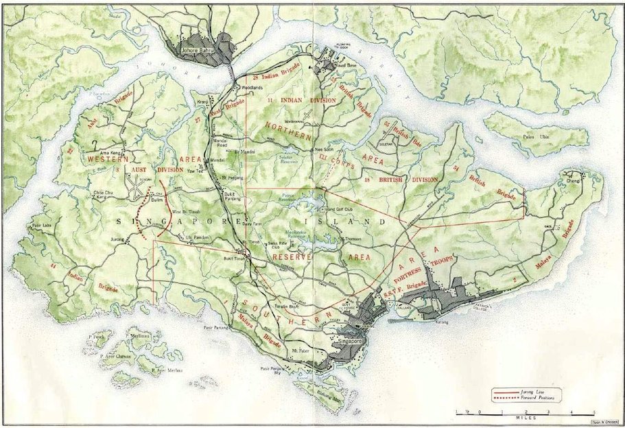
The British military map above shows the dispositions of the British Empire forces on the island in 1942 just before the Japanese invaded. Only 13 years later I with my parents and sister arrived in 1955. The first thing that catches the eye is just how small the island really is if you check the MILES scale.
If you are interested in what happened during the Japanese invasion in 1942 – here is a link to an excellent Wikipedia description:
That the Japanese nation had been systematically brainwashed is now common knowledge but it is still hard even to this day to comprehend just how inhuman they were in their treatment of any other being apart from themselves. By far the population of Singapore was predominantly Chinese who the Japanese regarded as having a lower status than a dog. We had a Chinese Amah in Singapore who was only a teenager when the invasion occured.
One day a Japanese soldier accosted her on the street and with his bayonet sliced open her leg then dragged her to a store front where he demanded salt which he then packed into the wound. Just for fun as his fellow sadists shared his laughter. She was lucky in the sense that she wasn‘t gang raped and then disemboweld. Bugis Street of world renown is a street which in the evening turns into a kind of open air restaurant with food stalls popping up all over the place complete with tables and chairs for the clientele. The main attraction of the street however is that it is a „red light“ district where the „ladies of the night“ intermingle with the crowd. There in the post-war years you could meet the famous Chinese „Mama San“ who everyone affectionately called „Dum Dum“. She got this name because the Japanese had cut out her tongue.
The island is separated from the Malaysian mainland by the Johore Strait however there is a broad motor/railwayway causeway across the strait connecting the island to the Malaysian town Johore Bahru. If you look to the east of Johore Bahru on the map you will see „Naval Base“ marked on the island. This was the large Sembawang Royal Navy base with floating dock facilities. In 1955 not much on the island had changed since 1945.
The RAF had built a base at Changi on the eastern tip of the island which was mainly for fighter squadrons but also had Shackleton bombers used for reconnaisance. The airfield was sighted not far up the road from the infamous Changi Jail. In 1942 Tengah was the largest RAF airfield on the island
which after the war became a base for RAF bomber squadrons. There was also a large army base called Alexandria but it is not shown on the map. Paya Lebar was the civilian international airport sited on the east of the island but also not shown on the map. I lived first in Seletar and years later to the west of Katong on the beach front at the south of the island, just east of Singapore City.
On the map you can see on the NE of the island an airstip drawn just above SELETAR; below an aerial photo of the same area.
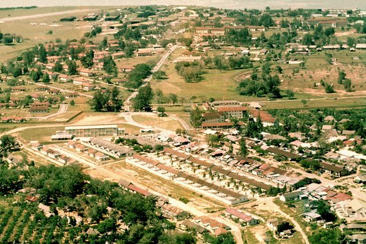
The airstrip can be seen at the top left corner of the photo. From the center left of the photo you can see a perimiter fence which runs horizontaly to the right and then zigs upwards where it once again runs horizontally. Where the zig stops there is a bunch of trees through which runs a main road. This is the main entrance to RAF Seletar and everything north of the perimeter fence is part of the air force base.
The blocks of flats with red tiled roofs just SE of the main entrance is also enclosed by a perimeter fence. This is where the families of GCHQ personnel lived and where I grew up. It was not a part of the RAF base . Just below the red tiled roofs is the village of Jalan Kayu and the main road running through it to the main gate had the same name.
RAF Seletar had squadrons of Vampire and Meteor jets based there but also was home to RAF Sunderland flying boats at a seperate section of the base – their main maintenance hangar can be seen at the top right corner (five white dashes). Directly opposite the main Sunderland maintenance hangar was the RAF Yacht Club where my father had a yacht and I had a boat which was built by a Chinese boatbuilder.
To top it all off the RAF had also built an excellent swimming pool and the „ASTRA“ cinema within the base (where I first saw „The Cruel Sea“). The streets all had English names like Picadilly Circus and Oxford street and the officers married quarters were to be admired most of them being built to a kind of Tropics-Tudor design.
Jalan Kayu village had also plenty on offer. Simple small but good Chinese restaurants, general stores, tailor shops, Suzi Wong type bars (for the airmen!) and second-hand paperback bookshops! Apart from schoolbooks the only things to read available in my age group were US comics which I soon got bored with. I used to go into the 2nd hand bookshops and gawp at all the artisticaly drawn paperback front covers and that‘s when I soon met Audie Murphy. „To Hell and Back“ - the first real book I had ever read in my life and I was hooked! Next up -“The Dam Busters“, „The Colditz Story“, „The Wooden Horse“ and on and on and on – thank you USA for showing me the way!
Below a few photos of RAF Seletar:
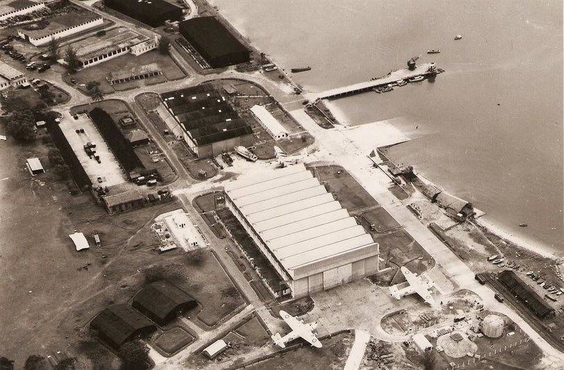
The Sunderland maintenance hangar at the center. Three Sunderlands can be seen on the tarmac. The slipway/ramp where the flying boats were wheeled up from or down to the sea on support trolleys is just above the yacht club which itself is directly opposite the hangar. Above the ramp is a pier with a crane and a control tower. This is from where the RAF crews and supplies were ferried with RAF launches to the operational Sunderlands which were moored to buoys out in the Strait.
The photo appears a bit sad but would give a completely different impression if in colour as can be seen by the artists impression below:
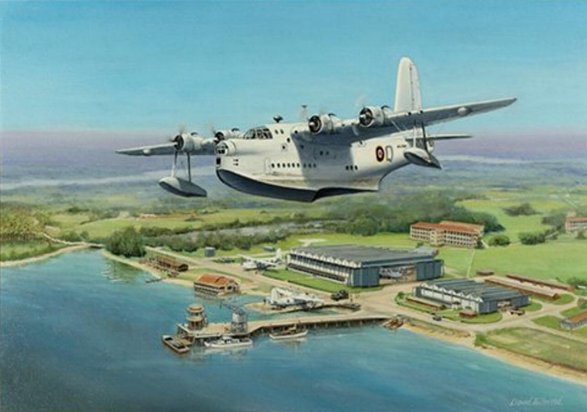
I cannot decypher the artist‘s signature but he has captured the scene exactly showing the lush green of the terrain, the yacht club buildings, the pier with control tower plus crane and launches. A Sunderland on the slipway, the red-roofed barracks buildings, the blue of the Strait and last but not least the magnificent Sunderland.
End of Chapter 7, continued in Chapter 8...